Without Further Ado…
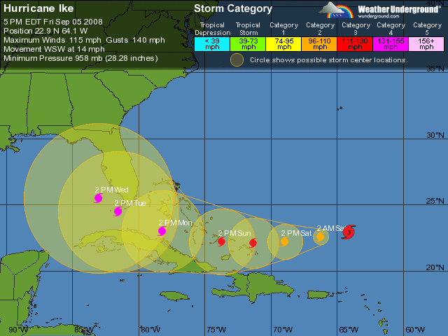
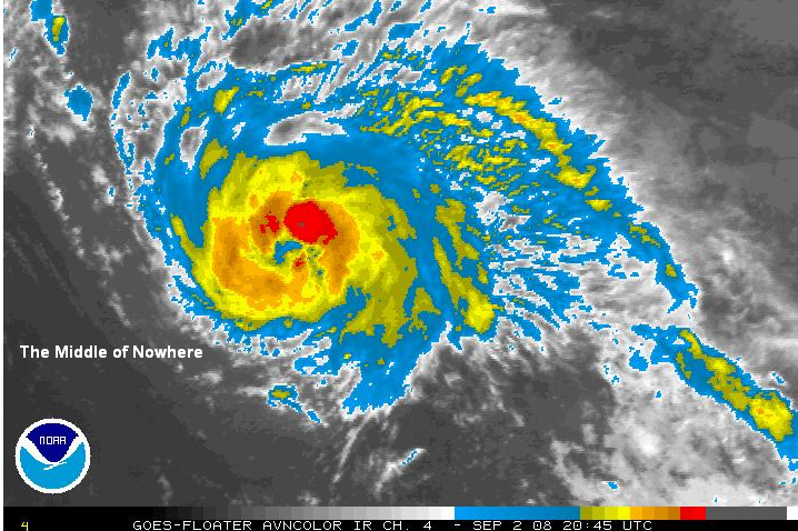
Tropical Storm Hanna

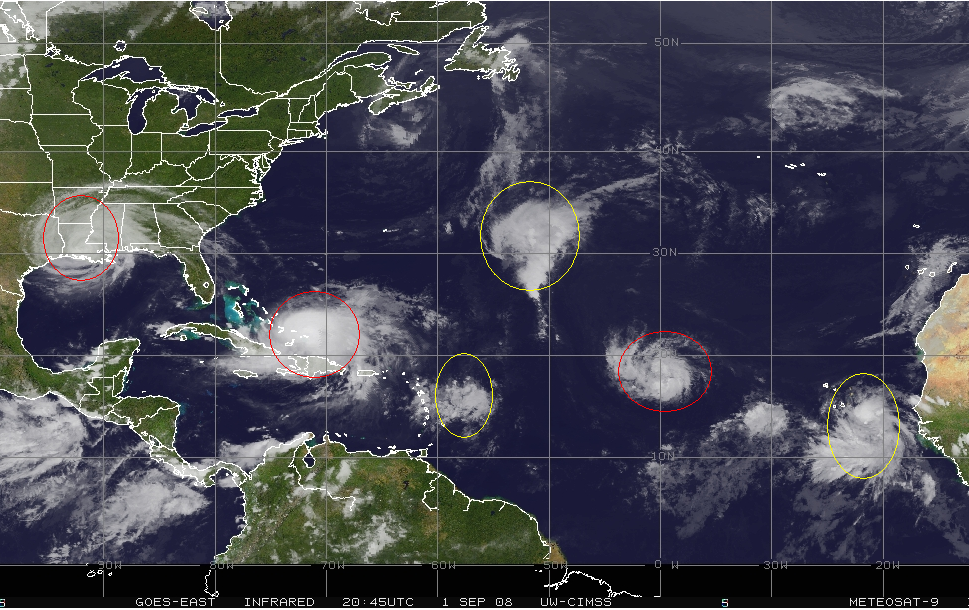
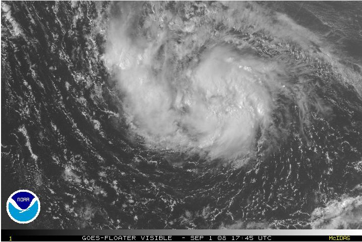
Image: A very broad, disorganized TS Hanna which has the appearance of some sort of sub-tropical hybrid. Note Ike in the background beginning to run into its outflow.
Last night, I dreamt I was a coroner. In my left hand, I held a pen and was preparing to write a “Time of Death” notice for Tropical Storm Hanna (12:00 am. Cause: Wind Shear). In my right, I had a telephone and was on hold with the cops, waiting for them to issue warrants for the arrest of Gustav on suspicion of “cyclocide.”
Fortunately, the ER nurse rushed in at the last second and defibrillated the hell out of her until she woke up. Unfortunately, the whole episode messed with the poor girl’s head and now she thinks that she is a mid-latitude system rather than a tropical storm.
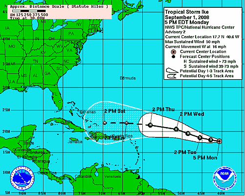
Indeed, late last night, Hanna looked dead. It had been sheared apart and was drifting aimlessly towards Haiti. But after 3 long days, wind shear from Gustav’s outflow has finally slacked from 30 knots to a more reasonable 15 knots and Hanna has finally started to move to the NNW and strengthen. Hanna’s winds remain 60 mph. While this storm is of no interest to those hoping for a bounce in energy, people living in the big cities of the east coast should get ready for a very wet and windy weakend. Since the storm drifted east longer than expected, model guidance has summarily followed suit and instead of a Florida/Georgia/S. Carolina landfall, a N/S Carolina landfall looks likely.

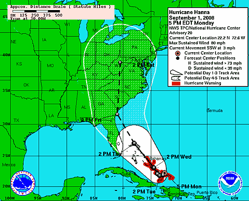
Image: Latest NHC track showing a track up the east coast.
After landfall, the storm will continue north, wrap up even more, and give the big cities from D.C. to Boston between 3-6 inches, along with tropical storm force winds. Get excited. Hanna is a very large storm with winds extending out nearly 300 miles from the center. As the storm strengthens,I would not be surprised to see its windfield contract some, but it will always be a broad system.

Image: Latest GFS model precip estimates through Sunday showing a swath of >3 inches for the major cities.
The NHC takes Hanna to an 80 mph hurricane at landfall, which I feel is somewhat ambitious given the 15 knots of shear over it and its large, disorganized state. The center of circulation is completely exposed from its convection and until they become co-located the storm will not significantly strengthen (Let’s not have any cracks like “Hanna’s naked!” Show some respect for the poor girl). In fact, the storm looks slightly subtropical, or mid-latitudinal, with most of the convection and strong winds well away from the center. Such storms are both slow to strengthen and slow to weaken once reaching the caost. I expect it to landfall with top winds somewhere between 65 and 75 mph.

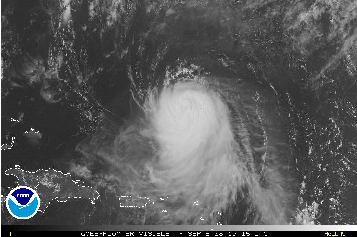
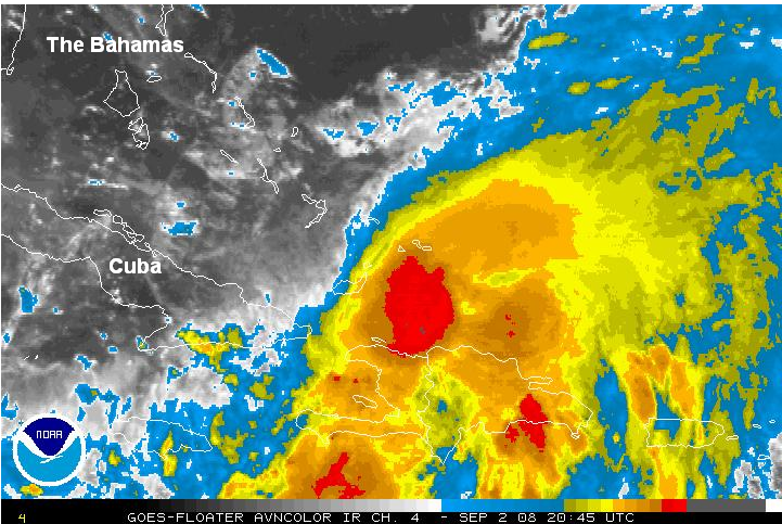
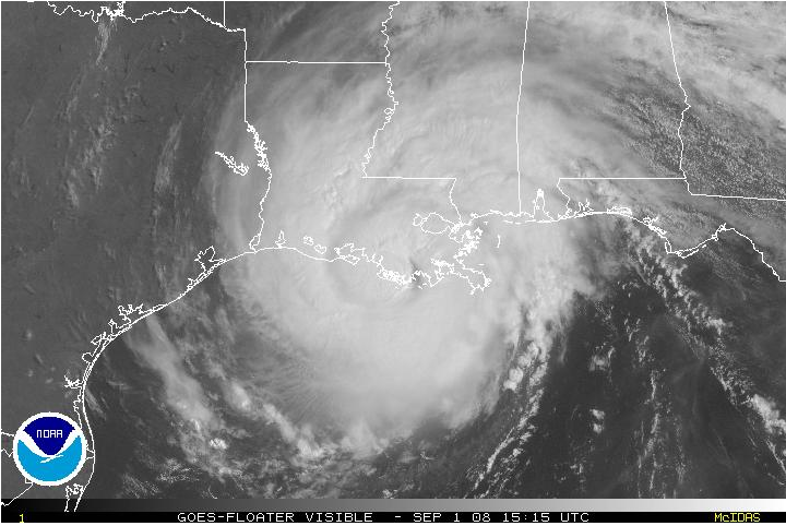
Image: Visible satellite showing a faint swirl where the center is, well to the south of the strong thunderstorms.
.
.
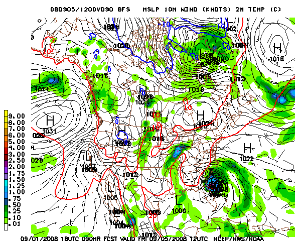
Hurricane Ike

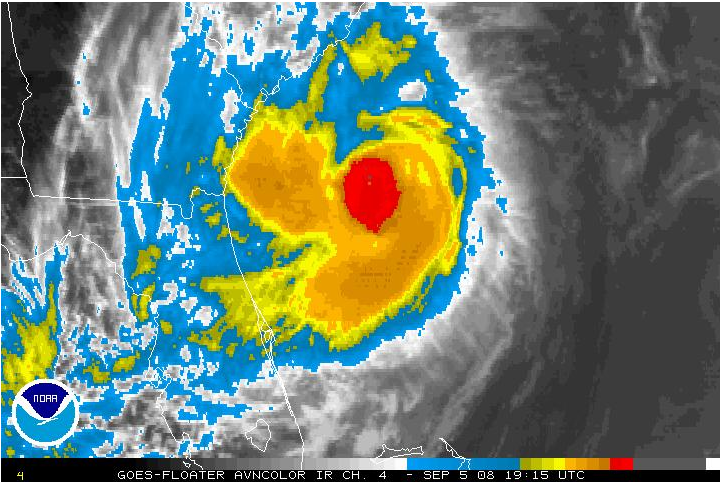
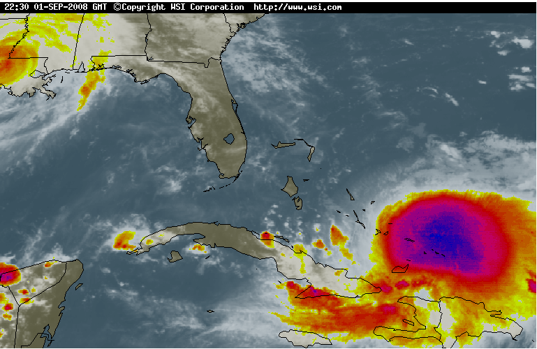
Image: Latest IR satellite of Ike showing the third major hurricane of the season.
So I had finished the post and was nearly ready to send it. I had mentioned in my discussion of Ike that despite the NHC’s 5pm wind speed of 80 mph, it really looked closer to 95-100 to me and that in the 11pm update it would probably be necessary to upgrade. However, I just checked to see if they issued any sort of special update at 8pm, and I was stunned: 115mph! Ike’s windspeed jumped 35 mph in 3 hours. Impressive. Not to brag or anything but I kinda sorta called this a few days ago. I would not be suprised to see energy bounce a little bit on this news.
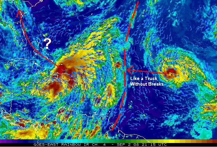
The has contracted somewhat during the past day but is still a classic Cape Verde storm. It is possible that Ike could reach Cat 4 status at some point in the next 24 hours before wind shear from Hanna increases and puts the kabash on any intensification. This will likely be a temporary condition and I expect Ike to re-obtain Cat 4, or even cat 5, status sometime this weekend. The NHC now shows the storm as a very dangerous Cat 4 in the Bahamas by the weekend.
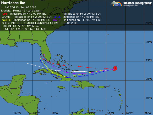
I am getting a little bit concerned about the track. According to the official forecast, and a majority of the models, the storm should continue moving WNW, interact with a blocking ridge, dive SW into the Bahamas, and turn back towards the WNW late in the forecast period.

Image: Latest NHC track of Ike, showing a very dangerous Cat 4 in the Bahamas.
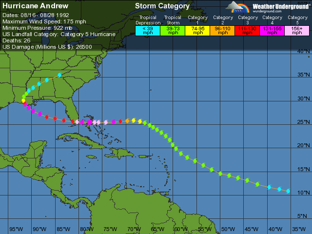
This is a great track for those hoping for another gulf storm and, due to the consensus, a pretty good bet. I give a track within 200 miles of the current forecast a 60% chance of occurring. Should the storm follow this guidance, the path reminds me a lot of Hurricane Andrew from 1992.
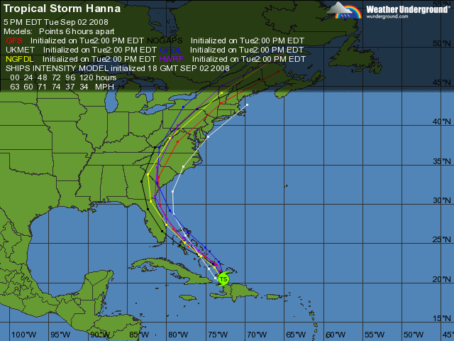
However, as I mentioned yesterday, climatology absolutely despises this track. In addition, I am somewhat concerned by Hanna’s sluggishness and strength. The longer that Hanna hangs out in the Bahamas and the stronger it gets, the better chances are that it will create a strong enough weakness in the blocking ridge to drag Ike northward. Such a solution is proposed by the GFS and UKMET models. Those wanting a Gulf storm: Tell Hanna to get a move on already.

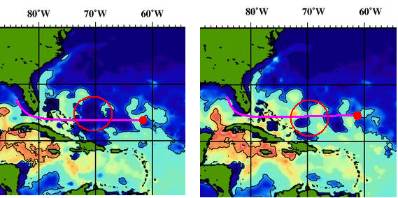
Image: Latest computer model runs showing a wave-like path. The GFS, not shown, indicates an even more northerly path than the UKMET.
Personally, at this time, I don’t think this one is going to get into the Gulf (sorry guys). A Florida landfall, followed by a turn up the east coast seems like a reasonable bet to me. This reminds me of the track of hurricane Floyd back in 1999, which was also a potent Cape Verde Storm.

Image: Track of Hurricane Floyd. Ike might follow a similiar track.
However, there is plenty of time to watch Ike and the forecast track is subject to change.I am not buying any more energy stocks right now, until Ike’s future becomes more certain. Feel free to disagree with me. In fact, please do.
One final thing. Ike’s rapid intensification means that it is more likely to feel the ridge, which could result in a further southward dive than is currently forecast. Likewise, it would also be more likely to feel when this ridge breaks down and curve more sharply.
I will keep an eye on VLO, NOV, and CHK for possible entries. I am still holding (In order of position ssize) CHK, VLO, RIG, and UNG.
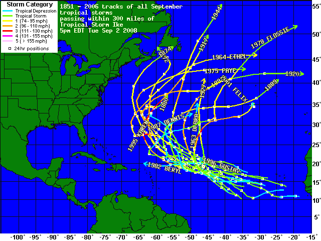
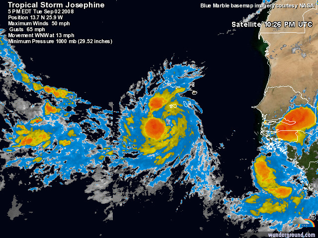
Tropical Storm Josephine
Josephine nearly became a hurricane this morning and remains a 60 mph TS, but it is beginning to feel the effects of some strong westerly sheer and decreasing SSTs. The NHC forecast knocks it all the way down to a 35 mph Tropical Depression by 120 hours, and I tend to agree with them.

One thing about this track: If Josephine does weaken, it will become a more shallow system that will be steered by the low-level westerly flow, which could delay, or even prevent, a recurvature. The stronger that it remains, the more likely it responds to weaknesses in the Atlantic ridge and recurves. If it can survive, but remain weak enough to continue westward, it might encounter more favorable conditions as it nears the Antilles. That being said, I still think the odds favor it being a fish storm, and I only give it a 25% chance of affecting land.
Elsewhere, the tropics are forecast to remain active with two waves moving off Africa that several models develop. In addition, an area of disturbed weather has developed in the Bay of Campeche, south of the GOM, that some models develop. These don’t usually move into the Gulf, but rather hit Mexico.
This is great
Black Gold On Black Tuesday

Yesterday’s selloff in Oil and Natural Gas was nightmarish, and I believe, overdone. Natural Gas supplies are 6.8% lower today than this time last year, Gustav has reduced output an unkown amount in the Gulf for at least two weeks, there is at least one more threat in the Atlantic, and OPEC is expected to cut production next week next week. Oh yeah, and demand might have fallen a little bit.

In my mind, these do not justify a nearly 20% decline in the price of natural gas and a 10% decline in oil. I’m not adding right now, but I think commodities are due for a bounce, hurricane or not.
It’s been big news that the hedge fund Ospraie, which managed $4B, folded yesterday after suffering 40% losses in 2008, 26% of which came in August. The fall of Ospraie makes me think of LTCM back in 1998, the year I first began following the stock market. LTCM managed a similar amount of capital (granted, they traded mostly bonds and leveraged it more than 25X) and their collapse and bailout marked the bottom of the 1998 downturn. Could Ospraie’s collapse, and any funds that follow suit, lead to a similar event in the energy markets? Just a thought.

Image Credit: Bill Patterson
Comments »