The tropics remain busy with four storms lined up across the Atlantic. Gustav is no longer classified as a tropical system but is delivering big-time rains to Arkansas, Louisiana, and Texas. Between 11am and 5pm we had four storms simultaneously active across the Atlantic. This has occured multiple times, lastly in 1999. The record is five, set in 1971, when Edith, Fern, Ginger, and Heidi were all active.
Gustav
I was not amused by today’s tape, not one bit. Still holding. That is all.
[youtube:http://www.youtube.com/watch?v=YLjhRtn9j4A&feature=related 450 300]
Video: My thoughts on the subject of energy right now.
.
Tropical Storm Hanna
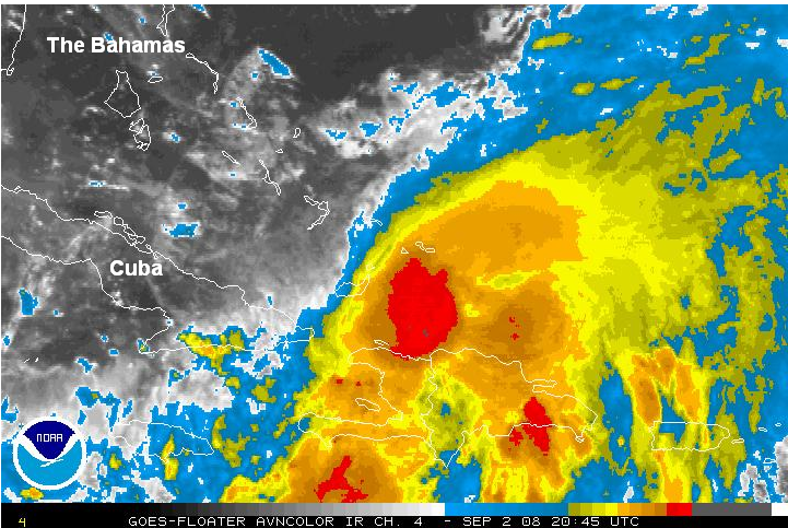
Image: Latest Infrared Satellite of Hanna showing a disorganized and sheared system.
Gustav, pissed that he couldn’t knock over a few oil rigs, poured out his wrath on Hanna instead. The 30 knots of wind shear induced by Gustav’s outflow finally had its way with Hanna last night, pushing the storm to the south and weakening it from 85 to 65 mph.
The storm drifted further south than anticipated by most of the models and has been pelting Haiti with heavy rain for the past 24 hours. This is the third storm in the past two weeks to impact Haiti, after Fay and Gustav. Pretty unfair for them. Pity there’s no NG in those waters. There remains excellent agreement among the models that Hanna will in short order turn to the northwest and increase her forward motion. This should allow the storm to brush most of Florida’s Atlantic coastline with rain and tropical storm force winds before making landfall somewhere in Georgia or Charleston. Personally, Savannah looks like a good bet.
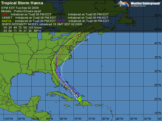
Image: Latest computer model runs showing very good agreement on a northwest turn. However, this move has yet to materialize.
Hanna is a very broad system and even should the storm remain 100 miles offshore, strong winds will still reach the coastline. Right now, the storm continues to slide slowly to the south and until it makes the turn, this is a relatively low-confidence forecast.
While there is good agreement on the track, the intensity forecast is more in question. Hanna is still struggling under about 25 knots of shear, but this is forecast to decrease to less than 15 knots by tomorrow morning. The storm is traversing the waters of the Gulf Stream with a high oceanic heat content ripe for strengthening, even rapid strengthening. However, broad, diffuse systems such as Hanna are sluggish and often have difficulty quickly wrapping up and intensifying (Think: Shaq vs. Usain Bolt in the 100 meter dash). The GFDL, HWRF, and SHIPS all take take Hanna to a 75-85 mph Cat 1. Based on its current appearance, it has a ways to go to reach that stage. I give the storm a 20% chance of moving over Haiti and dissipating, a 50% chance of remaining a TS, and a 30% chance of re-strengthening into a hurricane.
.
Tropical Storm Ike
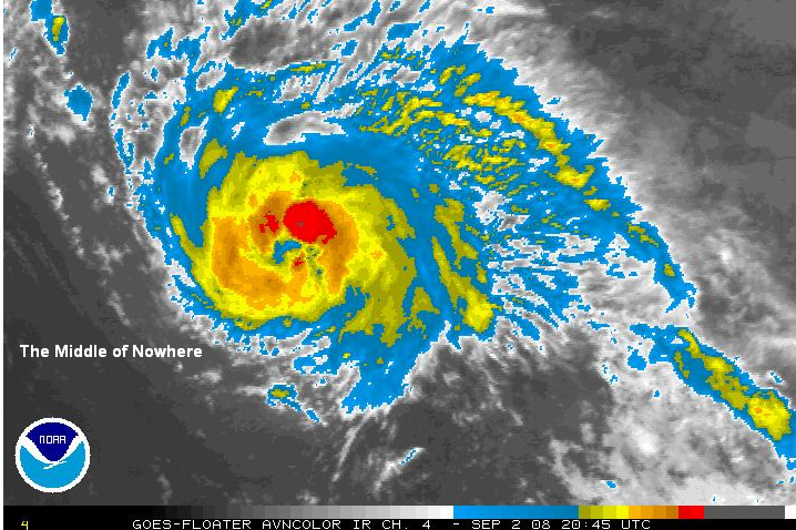
Image: Latest Infrared Image of TS Ike showing a strong storm approaching hurricane strength.
Ike is a 65 mph tropical storm and continues to organize as it races to the west over the open waters of the central Atlantic. Since its birth, It has been fighting a battle against dry air that recent satellite images show that it is beginning to win. Convection has completely encircled the system and is protecting the core. A false “eye” feature is also visible. Ike is a classic Cape Verde-type storm: Large, fast moving, symmetrical. I still believe that this has the potential to become a very dangerous storm. I expect it to become a hurricane within 12 hours, and possibly reach Cat. 3 strength as it approaches the Bahamas.
However, there are a few things that might hinder its development. First, several models suggest that westerly shear might increase after 48 hours. Second, other models show that a strengthening ridge will be strong enough to actually induce a WSW motion that could take Ike into Haiti or Cuba which would severely disrupt it. The third issue is perhaps the most obvious, but has not been discussed by the NHC. Unless Hanna gets itself into gear soon, Ike is going to run straight into its outflow by tomorrow. Gustav’s outflow knocked 25 mph off Hanna’s winds last night, and since Hanna is both a larger, and closer storm, it could do worse.
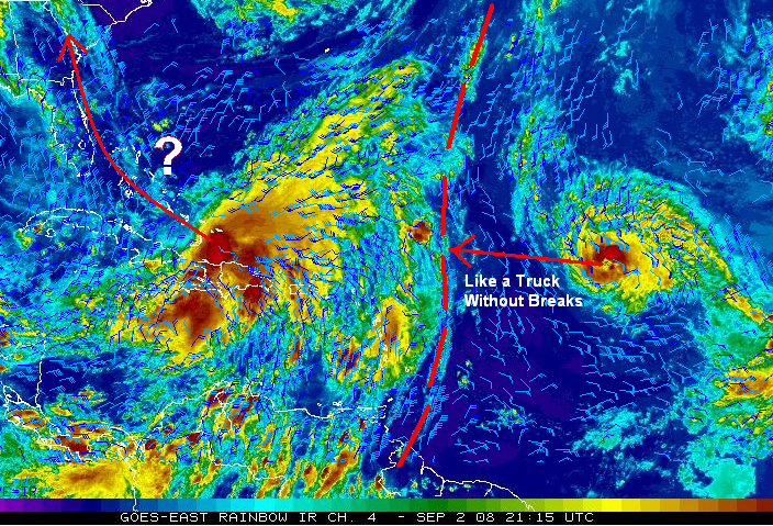
Image: Infrared satellite image overlaid with the upper level winds. The red line represents the longitude where, assuming Hanna doesn’t make much westward progress, Ike will encounter hostile westerly shear.
There is good agreement that the track will continue west to west-northwest for the next 72 hours. However, beyond this, the models diverge. On the northern extreme, the ECMWF believes that Ike will be dragged north by Hanna and impact the Carolinas. The GFDL is on the southern extreme, predicting a WSW track into Cuba. The other models lie somewhere in between. I like the NHC’s forecast track which tracks Ike pretty much westward through 120 hours, strengthening it to a 105 mph Cat 2. Floridians should be keeping a particularly close eye on this storm.
One thing that Ike does have working against it is climatology.
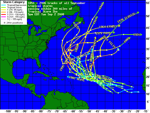
Image: Other Tropical Storms passing within 300 miles of Ike during September
Based on the above chart, no storm in the month of September within 300 miles of Ike has ever made it west of 67W, much less struck land. While I don’t tend to put much stock in climatology, this is pretty significant. Ike will definitely make it well west of all of those storms, at least to 75W, but there is clearly a tendency to recurve at some point. Syoptic scale meteorology always trumps the archives, but given this one-sided climatology, those in the Carolinas should keep an eye on Ike.
.
Tropical Storm Josephine
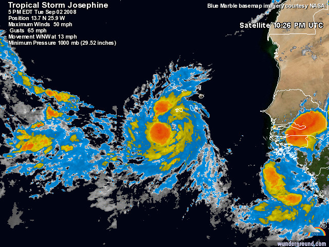
Image: Latest Infrared satellite image showing a very well organized storm, especially considering it just moved off Africa yesterday. Josephine is buffeting the Cape Verde islands with wind and rain today.
Tropical Depression #10 was born at 5am this morning and quickly upgraded to TS Josephine. Josephine is very far to the east, at just 25W. As I mentioned yesterday, such storms rarely impact land. While some of the models want to try to take the storm westward towards the Leeward Islands, I’m not really buying it unless it verifies in several more runs. Ergo, I still say that there is a 75% chance that Josephine will be a fish storm.
Josephine really is a “beautiful” storm, very symmetric, with large spiral bands. I think there is at least a 50% chance that it will reach hurricane strength at some point during its lifetime.
The other two threat areas that were showing interest yesterday have weakened and are not an immediate threat to develop. A monster wave is about to emerge off of Africa and we will need to watch this one for development.
I will be discussing the sell off in commodities tomorrow or Thursday, once damage estimates become available and I my pulse returns to appropriate levels.

Image Courtesy: Bill Patterson
If you enjoy the content at iBankCoin, please follow us on Twitter

No way Ike turns into a fish storm.
Ike is a bad mofo who hates GOM rigs.
One would think that once the damage is assessed, people will realize that while Gustav was “not as bad” as the storm of the century, it still disrupted shit in the GOM.
Of course, after applying Costanza principles, I see that disrupting supplies will cause prices to drop. Heyo!
With my luck, Ike will act like it’s been knocked with a pool cue, and hit that 8-ball known as Hanna straight onto my area of Florida beach. I double-spit on Ike. Go away!
Fly and DP…I really want to agree with you.
Boca…loving the analogy. However, when storms interact, they don’t really push eachother, but rather rotate around a fixed point between the two and slowly get pulled together. Its known as the Fujiwhara Effect. So, if Ike was going to have any effect on Hanna, it would actually be to pull it away from you.
This happens more often when the storms are stacked N-S, rather than E-W as are Ike and Hanna.
I like this Fujiwhara Effect stuff! Could be good news for me then, thanks for explaining, Veritas.
hurricanes are so 2005. wake me up when one actually does some consequential damage.
I find these posts are even more enjoyable after “three standard tokes” of “sticky wicky” from the industrial grade “bassoon bong.”
_________