Or, rather, please RSVP ASAP.
If you live in the Carolinas or the Northeast, pay attention. If you want to bank coin on a hurricane play, go back to watching football.
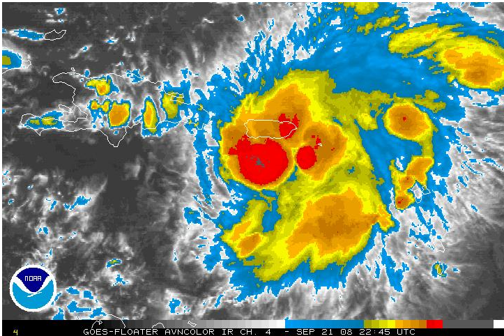
Image: Latest Satellite Image of “Proto-Kyle” hammering Puerto Rico.
The disturbance that I discussed on Friday has pulled itself together and is on the verge of being upgraded to TS Kyle. I give the system an 80% of being Kyle by this time tomorrow evening. The storm is centered just south of Puerto Rico and will cross the island in the next 12-24 hours bringing heavy rain and gusty winds. St. Thomas, located on the Virgin Islands to the NE of Proto-Kyle, recently recorded a wind gust to 40 mph.
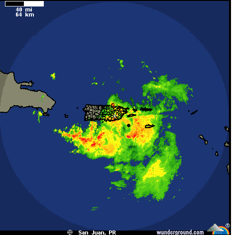
Image: Latest radar out of San Juan, PR, showing a large area of rain SE of the island.
The system will then track to the north into the Atlantic east of the Bahamas over the next 2-3 days. Once it is in that area, things get interesting from a meteorological perspective. There are four possible outcomes and I will briefly discuss each of them.
I.
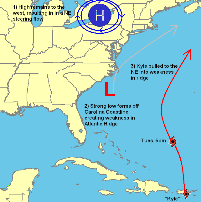
Image: Potential setup with a developing Nor’easter that does not interact with proto-Kyle.
The least interesting of the four. Most of the reliable computer models are predicting that the season’s first Nor’easter will develop off the Carolina coastline by midweek. If this system tracks the northeast, as most nor’easters do, it would open up a weakness in the Bermuda High and drag Proto-Kyle with it. In this scenario, Kyle would likely pass well east of the Eastern Seaboard with only peripheral effects, like high surf and possible beach erosion, affecting the US. This track is favored climatologically, but has been received with less enthusiasm in recent computer model runs.
II.
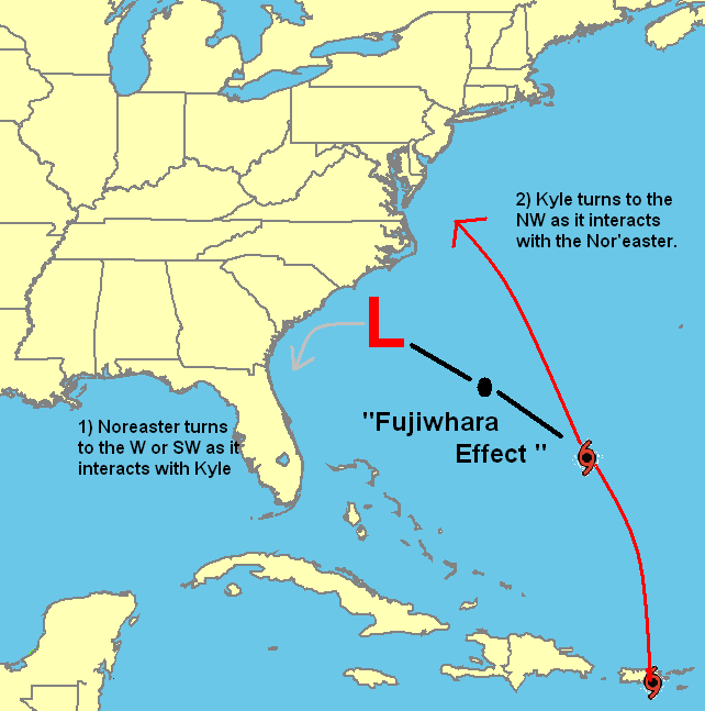
Image: Potential setup should Proto-Kyle interact with the developing Nor’easter.
Should Proto-Kyle put on a burst of speed, or this alleged Nor’easter develops to the east of where it is currently anticipated, the closer proximity of the two, will introduce the possibility of a rather unusual phenomenon: The Fujiwhara Effect. Under the Fujiwhara, two cyclones rotate counter-clockwise around a common fixed point located approximately between the two.
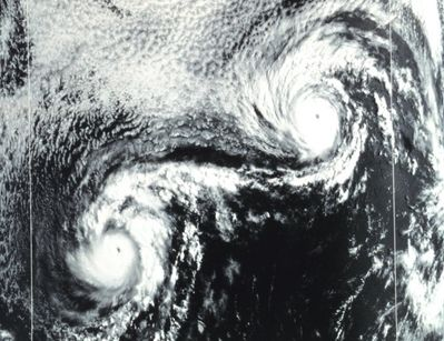
Image: Two cyclones displaying the Fujiwhara effect
If one storm is stronger than the other, it can draw the other towards it an eventually swallow it. This is what occurred in perhaps the most famous illustration of the Fujiwhara Effect during the 1995 hurricane season. Hurricane Iris would suck in and swallow Tropical Storm Karen in a form of Cyclonic Cannibalism.
The Fujiwhara Effect generally only occurs when storms are within 900 miles of eachother. Should the developing Nor’easter and Proto-Kyle fit this specification, the former will probably be steered the southwest towards Georgia, while Proto-Kyle is steered towards the Mid-Atlantic. The latest GFDL model run, which follows a Fujiwhara-based solution, takes a Category 2 storm up the Chesapeake Bay late in the week.
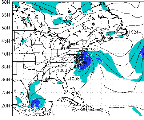
Image: GFDL model run showing a cat 2 hurricane approaching the Chesapeake Bay.
As someone who has lived in Virginia for about 12 years, this is a very dangerous track and reason for concern. A storm surge pushed into the Bay will be funneled northwards and pile up as it does so leading to greatly exaggerated flooding. It is far too early to discuss it, but there is a threat to NYC. The City has not had a serious hurricane since the 1938 “Long Island Express,” and a direct hit by a hurricane at any strength would be devastating due to unfortunate topography and development on the coastline.
III.
It is also possible that the Nor’easter will simply not develop as fully as the models are calling for. Anticipating cyclogenesis is not something that the computer models do particularly well. Should it not develop, Proto-Kyle would absorb its latent energy, and while not pushed out to sea, would be pulled northward parallel to the eastern seaboard. The latest GFS shows a very large, very strong storm just east of New England next Saturday.
IV.
It is also possible that wind shear from the Nor’easter will rip Kyle apart. Indeed, two storms in proximity is almost always a lose-lose for both parties involved. Each exerts shear on the other hindering development. In no way will the nor’easter enhance proto-Kyle’s development, at least not in a tropical sense.
In terms of which track is most likely to occur, I would like to introduce the concept of “Occam’s Razor,” which says that of all the solutions, that which is simplest is most likely to occur. Before 2008, I have found that the tropics obey this principle rather well. In this case, the “simplest solution” would be the first one, in which the Nor’easter opens up a weakness in the ridge and Kyle passes out to sea. However, with the very unusual tracks taken by Fay and Ike during the 2008 season, serious consideration must be given to all tracks. Right now, the track most favored by the computer models is a cross between (2) and (3) in which Proto-Kyle tracks northward followed by a bend to the northwest towards the coastline.
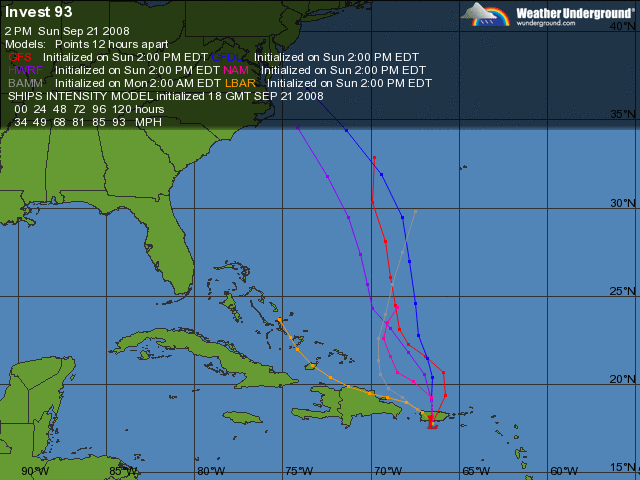
Image: Latest computer model guidance for Proto-Kyle.
Overall, I give Kyle a 50% of affecting the US coastline at some point in its lifetime. Personally, I think the track out to sea makes the most sense, and I would not be surprised to see the models shift east in upcoming days. However, until/if such a shift occurs, the east coast should keep a very close eye on the system.
As for its intensity, passage over PR should not inhibit develop significantly. Once it emerges into the Atlantic, the waters are warm enough for steady intensification, and several models are calling for it to reach hurricane strength. Once it moves north of about 30N, the waters cool and shear from the developing Nor’easter will begin to weaken the storm. I give the storm a 60% chance of reaching hurricane strength, but only a 25% chance of making landfall at said intensity.
Elsewhere in the Tropics, many of the models are calling for a tropical storm (Laura) to form between the Lesser Antilles and the African Coastline. Additionally, several are forecasting a tropical low to develop in the Gulf of Tehuanapec in the Pacific, track northward, cross Mexico and enter the Bay of Campeche and develop into a tropical storm.
Note: Today’s Patriot’s team was a fluke. If anybody says anything about Evil Empires and Karma, I will send Kyle right up your weedy, overgrown front lawn. Laugh it up. I dare you.

Image Courtesy: Bill Patterson
If you enjoy the content at iBankCoin, please follow us on Twitter

What does a hurricane forecaster do in the off season?
We bank coin off snowstorms.
So you are in the business of profiting off the misfortune of others. I think they call that ‘vulture investing’.
Not that there’s anything wrong with that!
Perhaps you’ll open a New Fund someday.
Juice,
A)That’s what investing is, profiting off the misfortune of others. Somebody always loses in a trade. How many people lost their livelihoods when Leh, Bsc, and FRE/FNM went down either being long those stocks or actually working there. Meanwhile, the good folks on iBC were raking in the profits long SKF, no questions asked.
B)Technically, I would be in the business of profiting off the threat of misfortunate to others. Ideally, you sell into the run-up leading to a storm (buy the rumor, sell just before the news) and then hope to god the thing misses. Seriously.
But you bring up a good point and it is something I probably should have addressed. Thanks for the post idea.
Going to Miami this Wed-Mon and this was the only info I could find online on Kyle’s predicted paths. Thanks much.